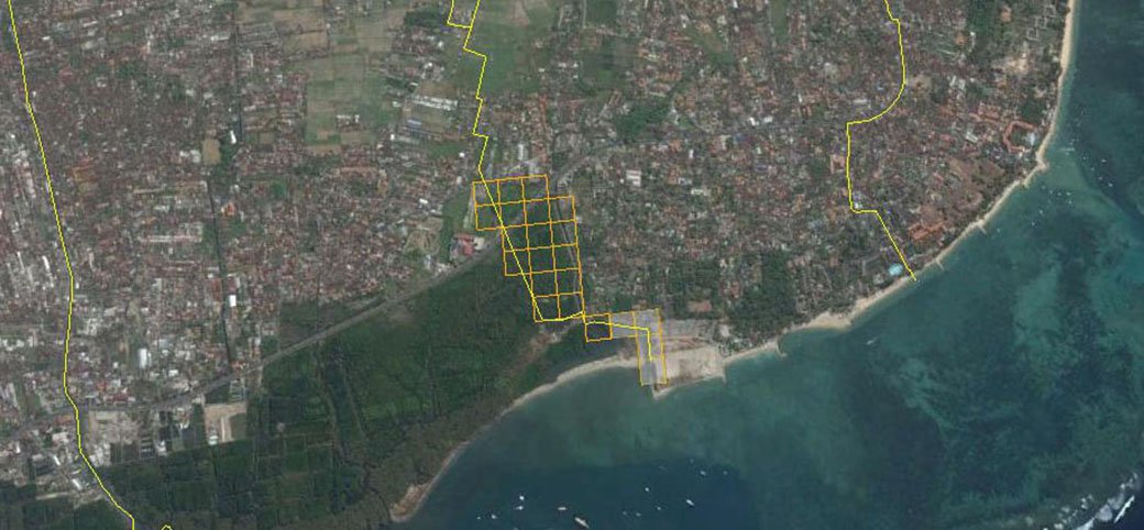
Sanur Kauh Area
Sanur Kauh is a village in the South Denpasar District, which is located in the southern city of Denpasar. Sanur has a coastline that is not less beautiful than Kuta area and elsewhere. From the '80s, Sanur area is so famous for its white sandy beaches have calm sea and big waves are not air. It is in the south and has a coral reef, making Sanur beach is very very special for the European tourist on holiday to Bali. In addition, Sanur also has mangrove areas, even though only 30 hectares, but has an important role to reduce abrasion around Sanur Kauh. Mangrove forest conservation area in the region Sanur Kauh often used as a planting site for a group of organizations, government agencies and private parties who care about the mangrove forests. Including FPMB, who several times in collaboration with public and private parties along the line planting Sanur Beach Kauh as an effort to improve the function of mangrove forests
Panjer Area
Panjer Urban Village is one of the villages in the region South Denpasar District administration. As one of the strategic location of the village that South region of Denpasar, Village Panjer South section has a mangrove forest conservation area covering +/- 105 hectares. Panjer region of mangrove areas have a fairly good plant density, so the plants can breed well. In addition to having the mangrove areas, Panjer also dealing dg waters of Benoa Bay side of the South. Panjer region FPMB activity is to perform monitoring and control routines scheduled around forest area using fishing boats.
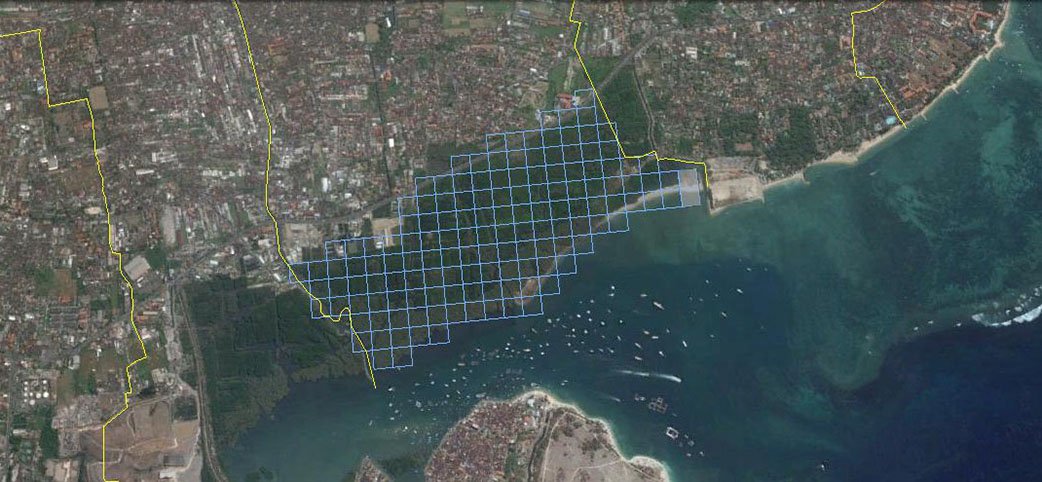
Sesetan Area
Sesetan urban village is part of the South Denpasar District administration. Having a mangrove forest conservation area covering 63 hectares located +/- South side of the city of Denpasar. Mangrove areas in the Village Sesetan alongside the waters of Benoa Bay. Prior to the access road to Serangan Island, the mangrove area in the Village Sesetan used by the residents as one point at dg crossing to the island attack using Jukung (traditional fishing boats) as alt transport to engage in persembhayangan. Tukad Rangda a point of access point connecting transportation between the mainland dg Denpasar Serangan Island. Currently, the access point Tukad Rangda is no longer used for connecting to Serangan Island. But the point the point is still being used by a group of fishermen as access to the open sea. Besides being a fishing access, mangrove areas in the Village Sesetan still being used by the people for the benefit of the indigenous as the location of Pura Dalam
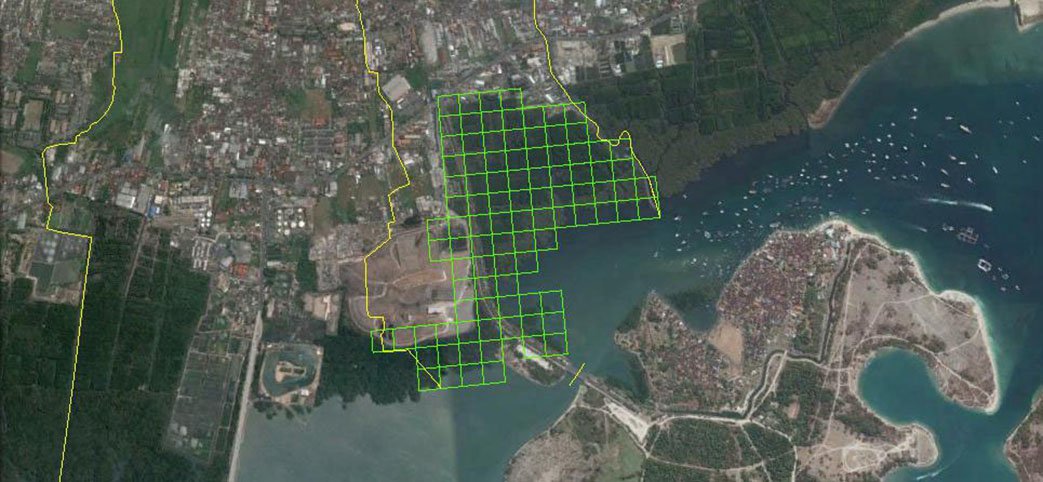
Pedungan Area
Pedungan is the Village South Denpasar District. Located on the South side of Denpasar, the region also has a mangrove forest conservation area covering +/- 95 hectares, which adjoin dg waters of Benoa Bay. Mangrove areas in the Village / Sub Pedungan can be seen along Jalan Pelabuhan eastbound access to the Port of Benoa Bali and the Bali Sea entrance Toll Mandara. Mangrove condition Pedungan region had experienced problems resultant liquid fuel pipeline leak, which caused the damage. Therefore, efforts as a form of vicarious liability is dg doing plumbing repairs, make a barrier so that the liquid does not spread widely, flushing liquid dg special material and next is to prepare the media back to later planted mangrove planting. Handling is done with the cooperation FPMB - Indonesia Power and the supervision dg Technician Execution Unit (UPT). Garden. Forests (Tahura) Ngurah Rai as a technical unit pengelolah mangrove forest conservation area waters Benoa Bay
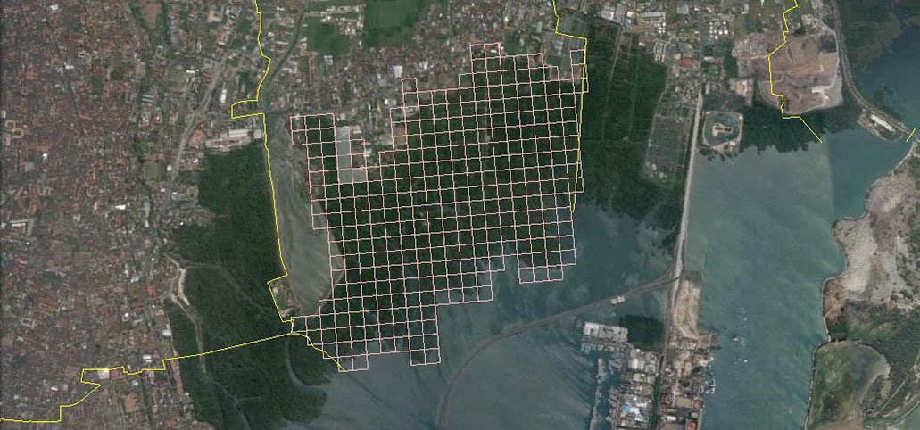
Pemogan Area
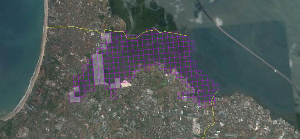
Pemogan the Village / Sub entrant in part adm South Denpasar District administration, Denpasar. Located on the south of the city Dempasar and Kuta area bordering the East. Pemogan side region of the South, has a mangrove forest conservation area covering +/- 277 hectares.Mangrove areas in this Pemogan Indonesian government is the result of cooperation with the Japanese government through the Japan International Cooperation Agency (JICA) in an effort to revitalize the function of mangrove forests that once was used as a salt pond by the surrounding community. This revitalization program implemented dg re groom, do replanting, and build supporting infrastructure such as the location of mangrove cultivation training, tracking roads, watchtowers and office BPHM Region I Bali. FPMB activity in this area is to perform service activities soaial cleaning plastic waste around streams and conduct training activities in cooperation dg yg BPHM Region I Bali
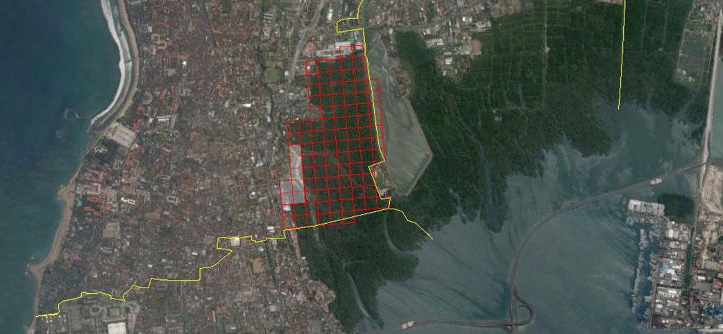
Kuta Area
It has been very likely, all travelers will get to know more than other areas of Kuta in Bali, maybe even in Indonesia. Administratively, Kuta Village is part of the district of Kuta, Badung Kabupateb. Kuta is the headliner tourism region with beautiful Kuta beach side of the west. East side section of the Kuta area has a mangrove forest conservation area which is quite spacious. Mangrove forest conservation area in the Kuta area of +/- 143 hectares of which are dealing with the Benoa Bay. Kuta area of tourism development today continue to experience an increase in facilities and infrastructure. However, when viewed from the East side of the Kuta area, then we will see a different view of the dg yg imagined by tourists. East side, we will be presented with the Watershed (DAS) headliner dg designation Tukad Mati. A steady flow of rivers that flow from the upstream portion region mencakip West Denpasar and Kuta area west bound downstream, namely Benoa Bay.
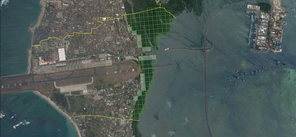
Tuban Area
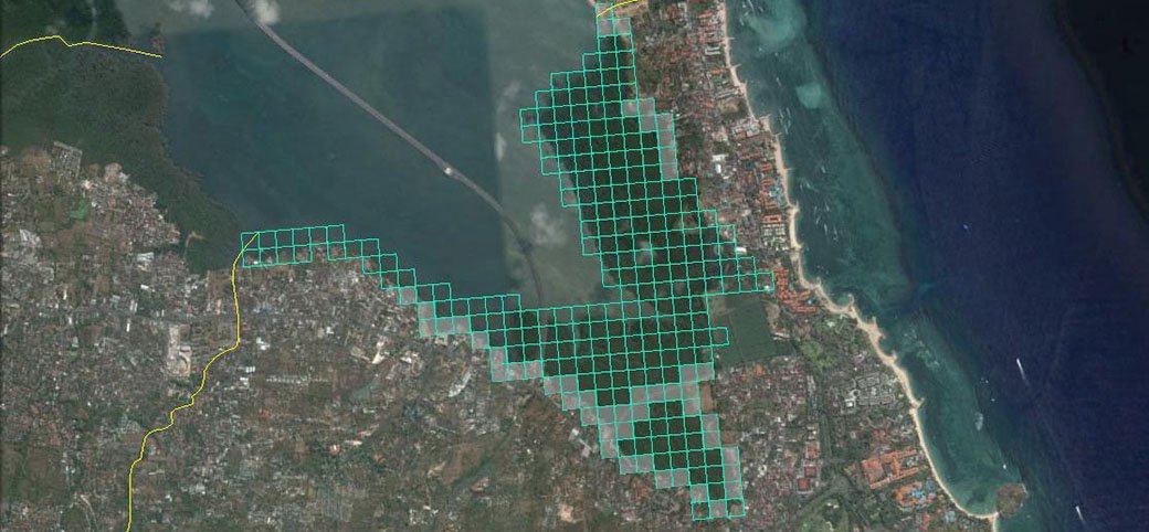
Village of Tuban, geographically positioned between the two waters, as well as the location of other regions in the southern part of the island of Bali. Tuban is the western side of the Indian Ocean coast, while the Eastern side section dealing with the waters of Benoa Bay, where the village of Tuban has Mangrove forest conservation area covering +/- 70 hectares. Construction of access roads Toll of the Sea and the development of Ngurah Rai International Airport, an impact, which is quite good, especially for local residents, and migrants who settled in Tuban village. This development creates conditions consequences either directly or indirectly, which is able to impact damage mangrove forest conservation area. Therefore, FPMB rescues around the mangrove area who are dealing with settlements, especially the densely populated area of Jalan Tepi Siring - Tuban. Locations which became the working area in the village of Tuban FPMB as much as +/- 45 points that spread from the border village of Tuban - Kedonganan up to the borders of the village of Tuban - Kuta
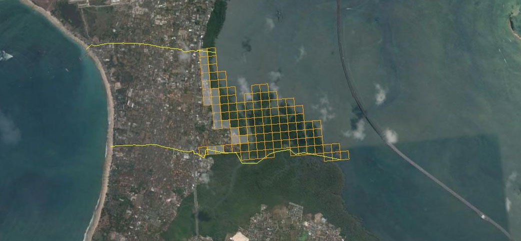
Kedonganan Area
Kedonganan the Village area that borders the village of Jimbaran. Village of Kedonganan entry into the territory of admisitrasi district of Kuta. Increased the area that is not too big, but very well-known as the Village Kedongan Eastern coastal areas that have a fairly complete fish market on the south island of Bali. Therefore, the supply of fish for the needs of restaurant and hotel in the southern part of Bali Island is supplied from Kedonganan Fish Market. Side of the East Village area of Kedonganan, there Mangrove forest area adjoining the mouth Benoa Bay. Has an area of +/- 96 hectares of mangrove forests, which did not escape the impact embossed on the little land inhabited that is growing and the number of domestic small industries, which are also increasing. Therefore, to preserve the mangrove forest conservation area, then FPMB conduct rescue efforts in some locations as much as +/- 27 points the location of which deal directly dg small industrial activity and houses around the mangrove areas
Jimbaran Area
Jimbaran, was one of the Village section of South Kuta District administration. Located exactly along the "neck" Island of Bali. Village of Jimbaran very popular with grilled fish restaurant locations that are along the Jimbaran beach side of the West. Jimbaran Village East side section, stretching the mangrove forest area of + - / 202 hectares of which can be seen from the Toll of the Sea and along Jalan By Pass to Nusa Dua. Conditions mangrove area in the village of Jimbaran has a characteristic that is almost similar dg Bualu Nusa Dua area. Ketinggihan has a density and mangrove trees that pretty well. Mangrove forest conservation area in the village of Jimbaran is quite vulnerable. Some findings in the field indicate that the region's mangrove forests under pressure from the activities of citizens, property development and industrial waste to small home appliances that have an impact on the damage and violation of mangrove forest conservation area. In order to keep the mangrove forest conservation area, FPMB prioritize rescue efforts in several strategic locations as much as +/- 34 point violations and damage-prone locations
Benoa Area
Benoa - Nusa Dua location not far from Tanjung Benoa, has a large area and is located on the South Island of Bali. Keluarahan Bualu is part of the administrative area of South Kuta District, Badung and renowned as one of the elite areas of tourist dg international convention center facility in BTDC area. Has a beautiful coastline on the south and also has a mangrove area of +/- 247 ha located in the crook of Benoa Bay Village East side Bualu. The mangrove area we can see from the Toll of the Sea and along the right-left toward Jalan Pratama Tanjung Benoa Village. Mangrove condition in this region has a density that is quite good, and in some locations, mangroves coexist with houses that have a variety of activities and community activities often have an impact on the damage and violation of the conservation area of mangrove forests. Therefore, FPMB reach several locations in the mangrove areas Bualu at +/- 85 point locations for conducting rescue Mangrove forest
Tanjung Benoa Area
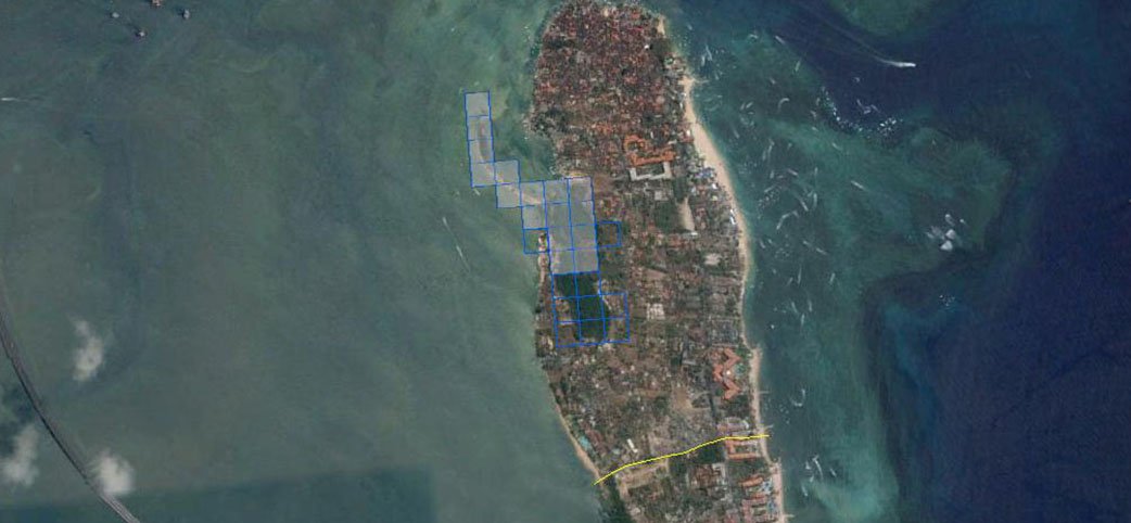
Village of Tanjung Benoa is an administrative area of the District of South Kuta, Badung Regency, located in the southern part of the island of Bali. Very strategic location flanked by the Indian Ocean coast of South side and Benoa Bay side of the North. Village of Tanjung Benoa in addition to famous tourist areas Watersport, there is also the Mangrove region that grows and develops along the northern coast of the Gulf of Benoa the extent of +/- 15 ha. Mangrove conditions in Tanjung Benoa quite alarming, Part of the community and local businesses using Mangrove periphery as location fixes ships fiber as well as a garbage dump. As one of the efforts to conserve the mangrove area, since 2013 has made the rescue efforts along the mangrove area of the Gulf of Benoa area of +/- 12 ha
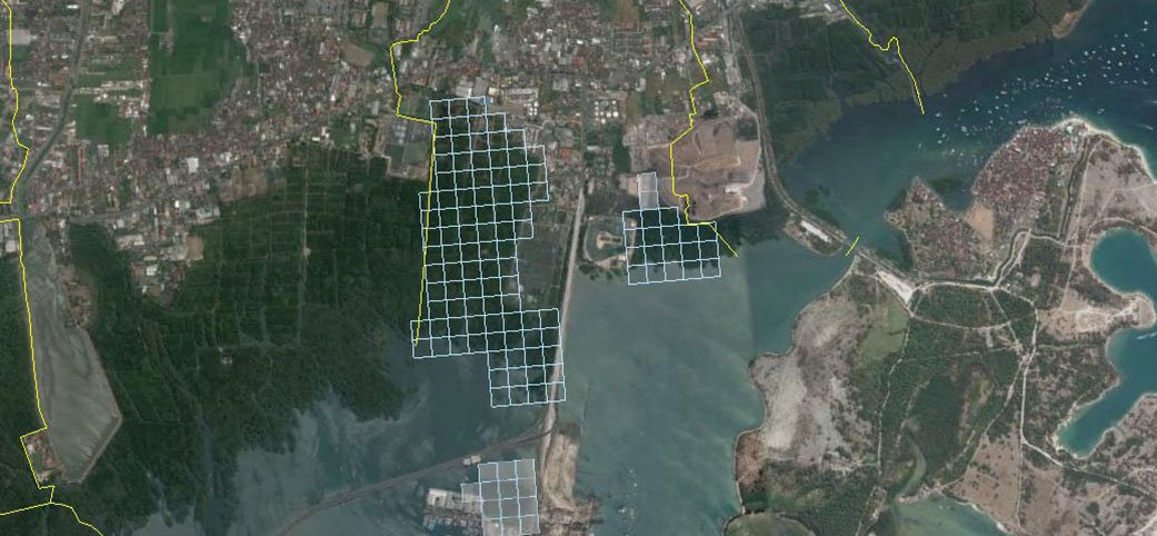
Serangan Area
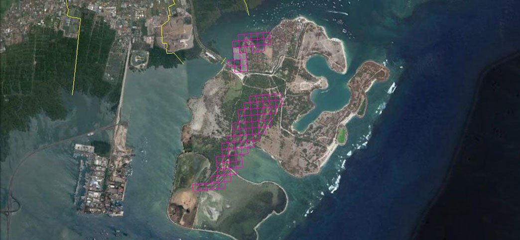
Serangan Village is a village located on the south of Denpasar, a village that belongs to the administration of South Denpasar District. Serangan is an island that was originally a separate land area of Denpasar. Having Sakenan Temple that is believed to be one of the important temples in Bali, and many residents who perform ritual worship to Serangan Island via the coastal path by using a fishing boat to cross the site of worship. Since the implementation of construction Serangan island by the developer in the early 90s, then Serangan Island have merged dg Denpasar. So that citizens who do worship to Serangan Island is no longer using fishing boats. In addition to having Sakenan Temple, Serangan Island is also famous for turtle breeding locations, and has a mangrove forest area covering an area of +/- 63 hectares. Of the total area of mangrove areas, FPMB conservation efforts in 23 locations of which are vulnerable to the impact of waste disposal and household waste